November 4, 1922 - Allen Chamberlain
A continuation of Allen Chamberlain’s trek along the proposed Wapack Trail
Including an explanation of the “Borden” marker
Some Relics of Olden Times

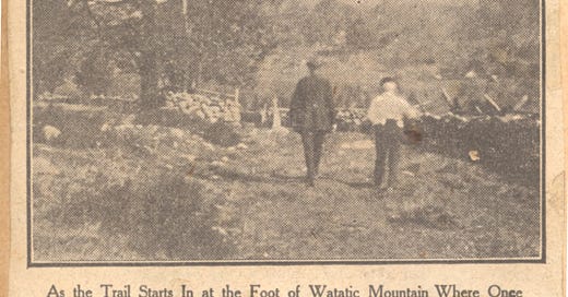
   From Ashburnham village in Massachusetts it is but five miles by an attractive road over Little Watatic mountain to e place where our walk began at a point the State road from Rindge to Townsend at the foot of Watatic mountain. where at an elevation of about 1200 feet above sea, and just west of the mountain, ere is a barway beyond which an old road is seen leading northerly across the open pastures and skirting around the mountain. Once upon a time, In the early part of the last century, when this was a post route between Boston and Vermont, a public house, known as the Children of the Woods Tavern, stood close by the barway. The old road through the pasture then led to a large and prosperous farm, settled by James Spaulding just before the Revolutionary War, and continued by his son-in-law, Jonas Nutting, until about 1840. The way is plain for three-quarters of a mile on the grass-grown road to the site of the old farm, where nothing now remains but the foundations of the numerous buildings, and the old wells, in one of which there still exists the stump of the old log pump.

   On Watatic mountain the Massachusetts Conservation Department maintains a fire watchtower, and if one has the inclination to visit it, twenty minutes of walking will be sufficient to take one up through the woods, following closely a property wall that is clearly seen leading southeasterly in that direction. The usual approach to the summit is from the northeastern side, the path beginning at the road leading to Now Ipswich from the State road. The outlook from Watatic is surprisingly comprehensive, considering that the summit is but 1850 feet above the sea, and only 600 feet above the surrounding country. Northerly lies the route of the trail over Barrett and Temple mountains to the Pack Monadnocks. Returning to the Nutting place the old road is picked up again where it enters the edge of the woods. Within a few rods crosses the town lines into Ashby, and almost immediately an east and west stone wall is encountered which is on the New Hampshire border.

A Scientific Landmark

   Just over the wall is a low stone monument, octagonal in form, and inscribed upon its top "Borden 1834." A little farther west on the wall is another larger monument, the corner where meet the towns of New Ipswich, New Hampshire, and Ashburnham and Ashby in Massachusetts. Few will know what that Borden stone stands for, however. It is not a State line marker and although it is located north of the wall it is actually in Massachusetts territory, for the wall was built too far south. It marks one of the stations of the trigonometrical sur- vey of Massachusetts made under the direction of Simeon Borden of Fall River back In the thirties of the last century, and which furnished the basis for the first accurate map of this state, On the top of Watatic Is one of the eighty or so hilltop stations occupied by that survey, and this stone back in the bush on the State line is one of the seventy or more secondary stations established incident to the work. Borden's name has been all but forgotten, and yet his work laid the foundation upon which all the subsequent mapping of the entire country rests.

   Beyond the wall the old road, which formerly ran on to New Ipswich, serving several other farms long since abandoned, is so brush-grown that it can only be followed by keeping close watch of the old side walls. Within an eighth of a mile an intersecting road is entered. A house once stood at these four corners, but we did not see its cellar even, so dense is the bush. At this point the route turns to the westward, still keeping between the walls of the old road, though even this guide is wanting in places, and one must take pains to keep the course which is generally west by north. As the road begins to drop down grade it becomes clearer, and at a point about a mile from the State line it emerges into a grassy but still traveled road. Turning east here for a distance of some 1500 feet another old road will be found on the left that bears away to the westward again. A sharp watch needs to be kept for this turning as it is in the woods and easily passed by unless one is on the lookout for it. This old highway formerly wound around to the south side of the little Binney pond, but the tramper will do well to leave it after a quarter of a mile or so and take a compass course northwesterly for an equal distance so as to pass the pond at its northeastern end, striking straight for the slope of Barrett mountain. The traveling is reasonably good through hardwood and pines that way, whereas farther to the west one encounters jungles of sprout, and impenetrable juniper and blackberry bushes on an old pasture.
Children of the Woods Tavern
One Hundred Formulas -
George Carmichael donated a copy of Stephen A. Thayer’s “One Hundred Formulas” which was published in 1883. It contains recipes from everything from printing ink to pain killers. Unlike some of the other formulas, this sedative drops recipe might actually work since hops and valerian have sedative properties. Not sure about the castor though.
This book sold for a dollar and was one of the many enterprises that Steven A, Thayer was involved with (He had a cigar factory too). He had some advice for preparing the recipes.
James Roger diary entry
October 21st 1908 (Wednesday)
Hard frost, ice thick on hen’s dishes. Cool day but no wind. David on roads down (town). I burned weeds in garden in forenoon and Mother and I lifted all the cabbages in the afternoon. I then put in the cows to eat up the cabbage leaves &c.


Wonderful piece on the history of trails and the construction of highways and byways in the region.
Seems like people were more at one with their environment a hundred years ago. Would be good for our young people to follow and clear parts of the Wapack Trail nowadays and desert their iPhones and TVs and virtual sense of belonging through social media.
The castor oil might have helped the valerian and hops go down the throat better re Thayer’s sleeping potion. However this foul concoction would have smelled and tasted terrible. Better to go hike the Wapack and wear oneself out with exercise and fresh air.
My father was born in Ashburnham and around 1920 my grandfather bought a farm that was mostly in New Ipswich but had one hayfield that he called the Massachusetts field, I think it was actually in Ashby. My father was an avid hunter (which I'm not) and we hunted the areas described above from the Mass border to Barrett and New Ipswich mountains and around Binney Pond. I followed some of these old trails and one occasion found myself lost deep in Massachusetts and had to hitchhike back to NH rifle in hand. I wish I had known this history then.